D1.1 Concept of Recommended Routing Corridors
The main aim of this document is to define the concept of “Recommended Corridors”. The principle is to use a large volume of tracking and position data from Satellite AIS, Terrestrial AIS and AIS from onboard vessels as well as weather data, to do big data analysis and provide recommended corridors for marine traffic based on the information about vessels which have sailed those navigable waters in the past. In this way HANSA may help to “streamline” traffic along the complete route, berth to berth, and create “virtual TSS”; the “virtual TSS” will in this case correspond to the way vessels actually travel. Read more...
D1.2 Corridors in Planning and Monitoring
This document gives a final definition of Recommended Corridors based on the initial definition given in Deliverable 1.1. As stated before, a large volume of historic AIS messages and historic weather data is analysed in order to derive traffic pattern. The analysis considers vessel’s attributes in combination with the prevailing weather conditions. Furthermore, this document presents the attributes of the vessels to be used for the analysis. One contribution of HANSA will be the calculation of Recommend Corridors for similar ship types. For this purpose, rules for grouping vessels will also be presented. Read more...
D2.1 Data Collection Report
This document presents the selected data sources, the designed data model and the architecture of the HANSA system. It provides description of sources that have been identified / available, the results of preliminary analysis of data samples from these sources and the list of sources that have been selected to be used in the HANSA project for generating the recommended corridors (Section 2). Further on, the document presents the proposed architecture of the HANSA system (both logical and physical) with components for data retrieval, fusion, storage and analysis (Section 3). Finally, the data model is described (Section 3). It was designed taking into consideration categories and types of the selected data as well as the goal to process and analyse the data in en efficient manner. Moreover, the data model focuses on optimization of data storage and required disk space. Read more...
D 2.1 Appendix 1 - Report on Preliminary Analysis of AIS Data
This document provides basic descriptive statistics about four vessel features: type, draught, dimensions, and destination. Following Raymond (2016), draught information is provided in two kinds of AIS messages. Type 5 messages (static and voyage related data) are the most common source of that information. Additionally, a subtype (with Designated Area Code set to 200 and Functional ID to 10) of type 8 messages (inland ship static and voyage related data) contains such information as well, but they are far less popular. Ship type information can be obtained from the two types mentioned above as well as from type 19 (extended class B CS position report) and 24 (static data report). Regarding ship dimensions, this information is transmitted in types 5, 19, 21 (aid-to-navigation report), and 24. Therefore, this analysis has been narrowed down only to type 5 messages, received in January-December 2015 from Orbcomm satellites (for the whole globe). The analysed dataset contains 1,390,219,742 messages from 425,166 unique MMSI numbers. Read more...
D2.2 Data Tools
This document presents the code of the methods and tools developed in the HANSA project related to the data retrieval, pre-processing and fusion. The code itself is available in the separate file. The code is organised in two folders, each represented by one of the following subsections. Read more...
D2.3 Data Fusion and Classification Report
Deliverable 2.3 aims at summarizing results of two tasks of the HANSA project – T2.4 Development of methods for data pre-processing and T2.5 Development of data classification methods. Therefore, this report focuses on presentation of methods and models developed in the project related to pre-processing, fusion and classification of data stored in the HANSA system. Read more...
D3.1 Data Processing Report
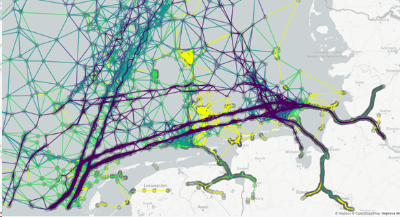
Deliverable 3.1 summarizes the results of Work Package 3 of the HANSA project related to Data Analysis. The aim of Work Package 3 was to develop and implement methods allowing to process the data collected on the earlier stages of the HANSA project. The methods presented here are based on Big Data technologies, allowing for an efficient processing of large datasets. Their objective is to generate a mesh graph (a conceptual representation of all possible routes at sea). Based on the mesh, recommended corridors might be then provided. The process and methods for generating recommended corridors are presented in Deliverable 3.3. Read more...
D3.2 Model for Recommended Routing Corridors
This document presents the code of the methods and tools developed in the HANSA project related to the generation of the mesh and recommended corridors as well as the web service for providing the results of these methods to external systems and applications. The code itself is available in the separate file. The code is organized in several folders, reflecting the repositories in which the code was developed. Read more...
D3.3 Recommended Routing Corridor Service
This document presents a web service that was developed in the HANSA project in order to make both the mesh and recommended corridors available to external components (e.g. systems and applications used by the project’s partners). A recommended corridor is provided by the service based on a query from external components, specifying e.g. a ship and a voyage for which the route should be planned. The service uses the mesh(es), previously generated by the HANSA system (a conceptual representation of all possible routes at sea, see Deliverable D3.1 and D3.2 for more details) to determine the recommended corridor. There are two types of requests available in the service: 1) provides the mesh for a specified maritime area; 2) provides the recommended corridor as the fastest or the shortest route, based on the data provided in a query. Read more...
D 4.1 (Web) Service and Configuration Tool
Subject of this Deliverable is the description of the developed algorithms in order to detect anomalous vessel behavior automatically. The automatic detection of anomalous vessel behavior is a challenge that arises from the expected further increasing traffic numbers at sea in the future, which will be accompanied by an increased collision risk. Automated sea area surveillance system that detects potentially dangerous and anomalous behavior and generates an appropriate alarm for the VTS officers is a promising pre-emptive action in this context.
Besides voyage planning, one aim of the HANSA project is to investigate on methods for automatic anomaly detection. This Deliverable describes the findings of the appropriate work package. Read more...
D 5.1 Corridors in Planning and Monitoring
The preceding work results of HANSA included data acquisition, preparation and analysis in order to extract the most common traffic patterns in form of a mesh. Based on this mesh, the Recommended Corridor is calculated, which can be accessed using an API. This API and its functionality to provide the mesh and Recommended Corridors will be referred as HANSA Services in the remaining document.
The aim of the work conducted in work package (WP) 5 is to integrate this API into the existing Maritime Safety and Security Information Exchange System (MarSSIES) that is currently applied by the Maritime Office in Gdynia to surveil the polish territorial waters in the Baltic Sea. In addition to this, the goal was to integrate the HANSA Services into the e-Maritime Integrated Reference Platform (eMIR), which is used to develop and test innovative maritime assistance systems.
This Deliverable provides a concept for the prototypical integration of the HANSA Services into MarSSIES and eMIR. Such an integration enables the evaluation and demonstration of the project results in a productive environment as well as in a testbed for maritime assistance systems. Read more...
D5.2 Integrated System
The aim of deliverable 5.2 is to summarize results of tasks of the HANSA project – T5.1 System integration and T5.2 Demonstration. This report focuses on presentation an effective approach to developed plan and refining the MarSSIES system (Maritime Safety and Security Information Exchange System) and eMIR (e-Maritime Integrated Reference Platform) by increase systems usability. Read more...
D6.1 System Test Report
The subject of the study is the summary of works related to testing the conducted integration of the MarSSIES with functionalities offered by the "Retrospective Analysis of Historical AIS Data for Navigational Safety Through Recommended Routes (HANSA)" project. The document contains a summary of information on the results of the tests of integrating the MarSSIES system with HANSA services, referred to the Work Package 5 of the project. Read more...
D6.1.1 MarSSIES Test plan - Attachment of D6.1
This Test Plan provides guidance for the testing management activities to be performed in support of the Maritime Safety and Security Information Exchange System (MarSSIES) system. The system has been extended with functionalities offered by the "Retrospective Analysis of Historical AIS Data for Navigational Safety Through Recommended Routes (HANSA)" project. This study describes planed test procedures and expectations for the new system modules. Read more...